-
Publish Your Research/Review Articles in our High Quality Journal for just USD $99*+Taxes( *T&C Apply)
Offer Ends On
Fatemeh Dargahian* and Samaneh Razavizadeh
Corresponding Author: Fatemeh Dargahian, Associate Professor, Research Institute of Forests and Rangelands, Agricultural Research, Education and Extension Organization (AREEO), Tehran, Iran.
Received: January 06, 2024 ; Revised: February 03, 2024 ; Accepted: February 06, 2024 ; Available Online: March 22, 2024
Citation: Dargahian F & Razavizadeh S. (2024) Climate Change and Precipitation Characteristics in Zagros, An Opportunity to Adapt and Reduce the Oak Decline. J Agric For Meterol Stud, 3(1): 1-15.
Copyrights: ©2024 Dargahian F & Razavizadeh S. This is an open-access article distributed under the terms of the Creative Commons Attribution License, which permits unrestricted use, distribution, and reproduction in any medium, provided the original author and source are credited.
Views & Citations
Likes & Shares
Arid and semi-arid regions are the most vulnerable to the super challenge of climate change and face severe and continuous droughts as well as irregular rainfall and massive floods. Zagros forests in Iran are located in a semi-humid to semi-arid climate. In the last two decades, these forests and especially the oak trees have suffered from pests and diseases with the increasing trend of temperature changes and rainfall irregularities, and they continue to decline and dry up every year. In this article, the rainfall potential that exists in this area and due to the characteristics of the shower, intense and short-term, has become a threat to these forests following the increase in temperature, investigated. To turn this threat into an opportunity, it is necessary to identify the characteristics of this potential. Precipitation indices revealing climate change determined by Expert Team on Climate Risk and Sector-Specific Climate Indices (ET CRSCI) were used. The slope of the trend, the error of the trend slope and the significance of each index, and the maximum potential of each index were extracted for 30 years. The results showed that although irregularity is part of the nature of rainfall, especially in semi-arid regions, in recent years, the intensity of fluctuations has increased and it has made it difficult to manage the water potential in Zagros, which benefits from two rainfall systems. The analysis of all the indicators showed that despite the extreme fluctuations, there is good water potential in the Zagros forest ecosystem, if managed through proper water management methods, water can be penetrated the ground and it is available to the long beards of the oak trees. In this way, it helped to preserve the forest ecosystem of Zagros and also contributed to one of the most important functions of Zagros as a supplier of freshwater reserves for a large population in the country.
Keywords: Climate change, Forest ecosystem, Precipitation potential, Zagros oak trees
INTRODUCTION
The Zagros forests in western Iran are about 6 million hectares, which are scattered in an area of nearly 30 million hectares. The reasons for the importance of Zagros forests are: The biosphere has a population of more than 10 million people, 50% of the country's livestock is in the Zagros basin, 70% of nomads live in this area, Zagros forests provide 40% of freshwater produced in the country. The forests of Zagros provide oxygen, they filter incoming dust from internal dust sources and neighboring countries, and they cause water to penetrate the ground and strengthen the underground water. There are 2,100 species of edible and medicinal plants in the natural area of Zagros, of which at least 470 species have been registered as having medicinal properties. Currently, 1.4 million hectares of the 6 million hectares of forests in the Zagros region are under destruction. And oak drying and decline have become a major challenge in it. Oak forests have grown in Zagros for many years and are a symbol of resistance. Oak trees sometimes endure thirst for more than eight months in the southern slopes of the Zagros forests in the heat of summer and play an important role in moderating the effects of climate change.
The decline of oak forests in the 1980s was reported in many European countries such as Italy [1], the Netherlands [2,3], etc. In the Mediterranean basin, Spanish authorities have officially recognized oak decline since the 1990s [4]. The first occurrence of KOW was in 2004 and the number of trees in Korea killed by KOW increased to about 331,000 in 2011which is attributed to the aging of trees and climate change [5]. This phenomenon is now widely known in all regions of the world that have this species. Therefore, oak decay is a global phenomenon. In Iran, the decline of oak forests in the Zagros forest ecosystem started in 2000; but in the last two decades, it has severely massively affected the forest and the extent of the areas involved in this phenomenon is continuously increasing [6]. Many biotic and abiotic factors have contributed to the decline of oak forests, the decline is related to some factors, including physiographic factors [7,8], soil factors [9]. And the factor of direction and location [10-12] has been investigated in different parts of Zagros. One of the most important factors of oak decline can be climate change. Climate change and especially temperature changes with increased evaporation and precipitation changes with decreasing humidity have provided the necessary ground for the presence of pests and diseases. The effect of climatic variables of temperature and rainfall on the width of growth rings of branched Iranian oak trees in the Middle Zagros region showed that rainfall and temperature had a positive and negative effect on the radial growth of trees, respectively [13]. The survey of the annual growing circles of trees in oak forests (Ilam province) showed that since 2001, the amount of growth has decreased, and the decrease in annual rainfall, the increase in dust, and the increase in temperature have caused the Iranian oak species to become stressed and become tense [14]. Investigating the relationship between climate and the cause of the oak decline in the forests of the Mediterranean region through dendrotechnological behaviors of healthy trees and decaying trees showed that the wood ring width is directly dependent on spring precipitation [15]. Comparing the width of growth rings and the size and number of vessels on the rate of disease between healthy and decayed oak trees (Dalab region of Ilam province) showed that most of the trees died in 2008. However, the data analysis showed that the symptoms of the disease appear several years before drying in the wood tissue [16].
Climate warming will increase the intensity and duration of droughts and heat waves. Therefore, climate change can increase forest destruction in many ecosystems of the world, especially in semi-arid forests [17]. Defoliation and the annual mortality of oak trees are not sudden and express the legacy of drought [18]. In the past decades, the increase in reported events related to tree mortality due to drought shows how climate change is changing forest ecosystems around the world [19]. The decrease in the number of trees in the oak forests of the Mediterranean region is a consequence of the simultaneous negative effects of climate change and excessive land use by humans [20]. Vulnerability to climate change events is strongly influenced by regional differences in climate impacts and the capacity to adapt to these changes [21]. In the Mediterranean basin, and especially in areas such as Tunisia, which have hot and dry summers, the mortality and decline of oak forests have been exacerbated due to the effects of climate change [22]. In temperate forests, oak tree decline and growth can be enhanced by climate warming and drought stress [23]. Therefore, the reduction of the forest area and the decline of trees is a global concern, and the Zagros forests in Iran are not exempt from this, and for this reason, one of the major challenges of Iran's natural environment in the last two decades has been the decline of trees, especially in the vegetation area of Zagros. Pourhashemi & Sadeghi [6]. This phenomenon is caused by several factors. The most important factors in the decline of trees are external factors, which weaken the trees and reduce their resistance and durability against habitat stresses and disease-causing factors [24]. One of the most important factors affecting the decline of Zagros trees is the change in climatic indicators [25-27]. Investigating the cause of the decline of oak trees in the Mediterranean region showed that the main cause was various biotic and abiotic factors, including climate change [28]. The relationship between climate anomalies and oak decline based on field observations in the Lucanian Apennines (southern Italy) in 2017 showed that a sharp decrease in rainfall in the first half of the year had an important role in the decline of oak trees [29]. A study of six oak species at 284 sites in eastern North America showed that oak radial growth was strongly related to growing-season precipitation and the ratio of precipitation to evapotranspiration [30]. The dependence of the radial growth of oak tree rings on the weather in the Majdanpek region of northeastern Serbia showed that the tree ring width has a prominent positive response to the amount of rainfall in the summer months and the current growing season.
The reduction of the area and the deterioration of forest ecosystems is a global phenomenon, and the Zagros forest ecosystem is not exempted from this due to its geographical location in a semi-arid and semi-humid area, it has faced a lot of vulnerability. From 2006 to 2018, the Zagros ecosystem faced a decrease in precipitation, an increase in temperature, and a long drought cycle. Many studies have shown a decrease decline and drying of the Zagros forests in Iran, a decrease in the crown coverage of oak trees in the forests of the Barm plain of Fars province [31], a decrease in more than 42,804 hectares of oak forests in Lorestan province in a period 2000 to 2016 [32], a 42% decrease in forest area in Ilam province [33]. The reduction of the area of forests in Ilam province between 2001 and 2013 by 26073 hectares [34], the reduction of the area of forests in Romeshkan city in 2017 to one-third compared to 1987 [35], reduction of carbon density between 2010 and 2015 related to the fall of oak trees due to various factors such as dust storms, pests and other diseases [36]. The effect of climate change on the deterioration and reduction of the area of north Zagros forests [37]. The occurrence of climate change in the forests of Zagros has been shown in the form of an increase in temperature and the irregularity of the rainfall pattern and the occurrence of extreme and torrential rains. In the Ilam region, a direct relationship between the climatic parameter of precipitation and the greenness of the trees in the region has been observed [38]. The study of forest loss in Durood, Lorestan Province showed that there is a close relationship between changes in the area of forest loss and rainfall and temperature [10]. One of the most important factors of deterioration can be climate change. Investigating the cause of the decline of oak trees in the Mediterranean region showed that the main cause was various biotic and abiotic factors, including climate change [28]. Examining the change in the concentration of chemical elements in the wood of decayed Iranian oak trees compared to healthy trees showed that among many factors, the incidence of decay is more influenced by climate factors [39]. A combination of climatic factors has played a role in the oak decline and drying [13,26,40-42]. Although some studies more on the temperature factor [43-45]. In some studies, the role of humidity has been emphasized [46,47]. Many studies have also shown the relationship between the decline and drying of Zagros oak trees and rainfall [16,38,48-50].
Climate change in the forests of Zagros has been shown in the form of an increase in temperature and the irregularity of the rainfall pattern and the occurrence of extreme and torrential rains. From 2006 to 2018, the Zagros ecosystem faced a decrease in precipitation, an increase in temperature, and a long drought cycle. The temporal-spatial analysis of drought and the drying of oak trees in Zagros forests in Ilam province showed that the drying of oak trees is spreading massively. Also, there is a significant relationship between the drought trend in spatial and temporal dimensions and the process of oak drying in recent years in different regions of Ilam [51]. The mechanism of occurrence and spread of acute oak decay disease was due to consecutive droughts and climate change in Zagros [52].
The complex nature of oak decline necessitates a holistic, multidisciplinary research approach for improved tree resilience in changing global climates [53]. A combination of human and natural factors, especially climatic variables, has been effective in the deterioration of the Zagros forests, but what overshadows human factors is largely climatic factors. Therefore, considering that climatic factors have been one of the most important factors affecting the drying of oak trees, in general, in some studies, the role of climatic factors such as average temperature, precipitation, humidity, and evaporation has been discussed, but the detection of climate change through the monitoring of global standard indicators of precipitation such as Limit profiles or extremes have not been done. Therefore, to adapt to the changes that have occurred and the changes to come, by knowing the characteristics of precipitation, which is the main goal of this research, the potential of precipitation in the area to exploit the available water capacity is identified and Sustainable forest management programs should be planned based on it.
METHODOLOGY
Study Area
The Zagros forests in western Iran are about 1265 km long and about 200 km wide in the widest places (Figure 1). The area of these forests is about 6 million hectares, which are scattered over an area of nearly 30 million hectares. Zagros forests make up 40% of Iran's forests, of which about 70% of the forest species are oaks (Figure 2). Over the past two decades, oak species have dried up for a variety of reasons (Figure 2 Image on the right). The Zagros forests are spread over 11 provinces in Iran. The average rainfall in this forest ecosystem is between 213 to 1335 mm (period 1990-2019). Irregular rainfall is a feature of the region, so the region has the potential for severe droughts and severe floods.
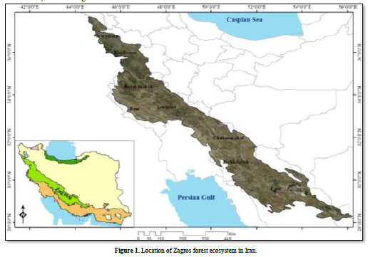
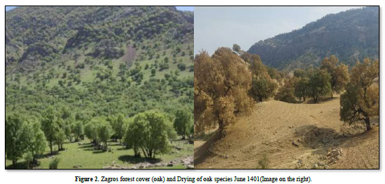
Iran has an area of 164 million hectares, 14 million, and 300 thousand hectares of forest land. Zagros forests with 6 million hectares have the highest forest area. 40% of the water produced in the country is due to the forests of the Zagros. During the last two decades, the trees of this forest ecosystem have declined for various reasons, including Drought, climate change, particulate matter, land use change, overuse of groundwater, construction projects without environmental attachments such as dams and road construction, declining populations of animals that help regenerate forests such as squirrels, over-entry of livestock to rangeland areas. One of the environmental problems of the Zagros forests in the last few years is the occurrence of the phenomenon of deterioration of oak trees, which has been manifested in them in the form of drying. This issue in Zagros forests is a multidimensional, complex, and national phenomenon [54]. Because the Zagros forest ecosystem is located in a semi-arid climate, it is very vulnerable to climate change and its rainfall is torrential and flooding. To adapt to climate change, these rainfall characteristics should be used as an opportunity for this. It is not possible to trust the average rainfall and plan based on it, so in this study, the rainfall indicators provided by Expert Team on Climate Risk and Sector-Specific Climate Indices (ET CRSCI) have been used to adapt to climate change and preserve the Zagros forest ecosystem.
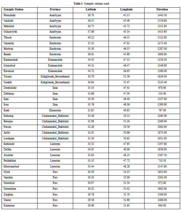
First, the location of the Zagros forest ecosystem was determined and synoptic stations were identified in its area (Table 1). Despite high-resolution network data, observational data was used due to its high accuracy. There are 58 synoptic stations within this ecosystem. Since, 30 years is a climatic period, 34 stations had the appropriate statistical period length.
The climatic parameters required to implement the climate change detection model were selected. Data included daily precipitation, daily maximum temperature, and daily minimum temperature. Before calculating the indices, the daily input data were checked for quality and homogeneity because homogeneity means the compatibility of a series over time and is an obvious need for a strong analysis of climate time series.
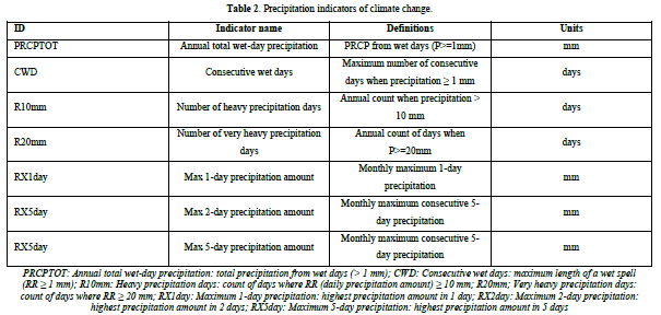
To calculate the indicators of climate change detection, ClimPACT software written in R environment was used. The ClimPACT software is based on the RClimDEX software developed by the World Meteorological Organization (WMO) Commission for Climatology (CCl) Open Panel of CCl Experts on Climate Information for Adaptation and Risk Management (OPACE 4) Expert Team on Climate Change Detection and Indices (ETCCDI). Data were entered into the software and the indices were calculated and extracted. Precipitation indices were selected from the output indices (Table 2).
These steps were performed for all synoptic stations in the whole area and finally, the selected indicators were zoned for the whole Zagros habitat. In this way, areas with good rainfall potential were identified and introduced to planners and decision-makers of forest conservation and rehabilitation projects.
RESULTS
Precipitation indicators revealing the occurrence of climate change
Annual total precipitation (PRCP)
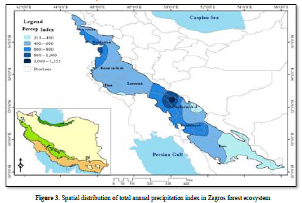
The zoning of the 30-year long-term average rainfall of Zagros showed that its rainfall ranges from 213 to 1335 mm.
The highest amount of precipitation in Chaharmahal and Bakhtiari provinces due to the presence of the highest altitudes of the Zagros mountain range and the location in the path of the two Mediterranean and Sudanese rain systems, which is more than 1000 mm, and then in Kohgiluyeh and Boyer Ahmad provinces, as well as in North Zagros, the average rainfall is between It is 600 to 800 mm, so the rainiest area of Zagros forest ecosystem is located in South Zagros (Figure 3).
Consecutive Wet Days (CWD)
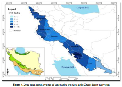
This index is one of the important indices to maintain the available moisture for different forest species. Reviewing the zoning map of the annual long-term average of consecutive wet days in Zagros showed that the highest number of consecutive wet days in Kohgiluyeh and Boyer Ahmed with -8 to 10 is the day after that, Chahar Mahal Bakhtiari and North Fars and North Zagros provinces have the highest number of consecutive wet days (Figure 4).
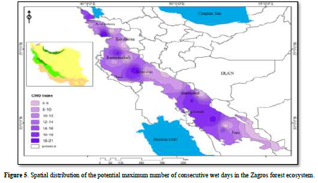
Examining the long-term maximum potential zoning map of consecutive wet days in Zagros showed that the maximum number of consecutive wet days corresponds to high altitudes in middle and southern Zagros and high latitudes in northern Zargos (Figure 5).
Number of heavy precipitation days (R10mm)
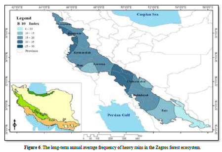
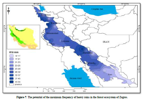
Examining the zoning map of the annual long-term average of the number of heavy rainfall events in Zagros showed that the highest number of heavy rainfall events is located on the border between Chaharmahal and Bakhtiari provinces of Khuzestan and Lorestan, as well as in the west of Kurdistan. The lowest number of heavy rainfall events is also located in South Fars (Figure 6). Examining the long-term maximum potential zoning map of the number of heavy rainfall events in Zagros showed that the maximum number of heavy rainfall events in South Zagros was 45 to 55 events in the north of Chaharmahal and Bakhtiari province and Kurdistan province (Figure 7).
Number of very heavy precipitation days (R20mm)
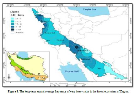
Examining the zoning map of the annual long-term average of the number of super heavy rain events in Zagros showed that the highest number of super heavy rain events is located on the border between Chaharmahal and Bakhtiari provinces of Khuzestan and Lorestan, as well as in western Kurdistan with -10 to 15 events. Very heavy precipitation is also located in the south of Fars and Ilam provinces on a long-term annual average (Figure 8).
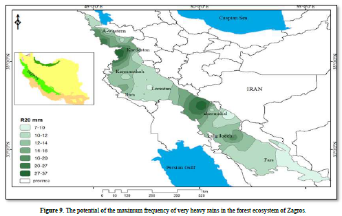
Examining the long-term maximum potential zoning map of the number of very heavy rainfall events in Zagros showed that the maximum number of heavy rainfall events in South Zagros was 27 to 37 events in the north of Chaharmahal and Bakhtiari province and Kurdistan province in North Zagros (Figure 9).
Max 1-day precipitation amount (RX1day)
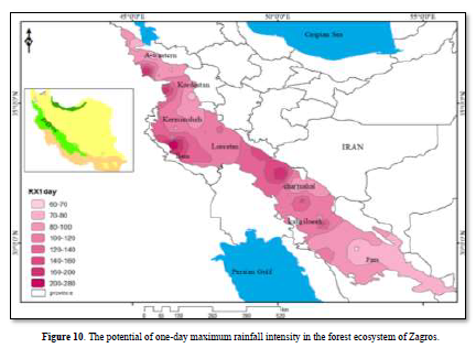
Examining the zoning map of the long-term absolute maximum potential of one-day rainfall intensity in Zagros showed that the maximum potential of one-day rainfall in South Zagros in the north of Chaharmahal Bakhtiari province and west of Ilam and west of Kurdistan reaches 200 to 280 mm (Figure 10).
Max 2-day precipitation amount (RX2day)
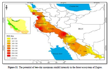
Examining the zoning map of the long-term absolute maximum potential of two-day rainfall in Zagros showed that the maximum potential of two-day rainfall in South Zagros in the north of Chaharmahal and Bakhtiari province and west of Ilam and west of Kurdistan reaches 200 to 280 mm. The areas of maximum two-day rainfall coincide with the areas of maximum one-day rainfall (Figure 11).
Max 5-day precipitation amount (RX15day)
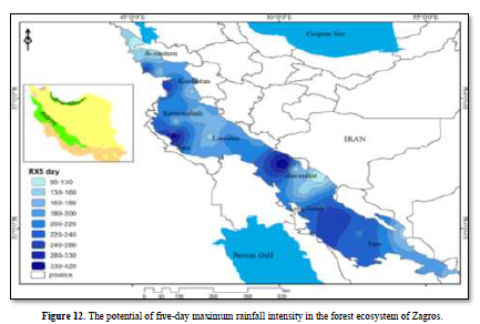
Examining the five-day rainfall intensity zoning map in Zagros showed that its long-term absolute maximum potential in South Zagros in the north of Chaharmahal and Bakhtiari province and west of Ilam and west of Kurdistan reaches 330 to 420 mm. The areas of maximum five-day rainfall coincide with the same areas of maximum rainfall of one and two days, with the difference that a maximum area has been added in the west of Fars province (Figure 12).
CONCLUSION
The forests of Zagros are located in a position that benefits from both Mediterranean and Sudanese rainfall systems and are located in the second-highest rainfall region of Iran, but due to the influence of global warming and climate change, its rainfall is not properly distributed. And it has been accompanied by floods and droughts, both of which are harmful to oak trees; the increase in intensity and decrease in the duration of rainfall has led to the occurrence of floods and turning rainfall into runoff and preventing trees from accessing sufficient moisture. The ground does not penetrate and does not strengthen the underground water, so in the years when drought occurs in the Zagros habitat, the extraction of underground water should be minimized [55]. On the other hand, the review of sources related to this research showed that precipitation is one of the most important factors that determine the decline of oak trees, and its role was shown in many studies. The characteristics of Zagros rainfall can be an opportunity to reduce the drying of oak trees and adapt to climate change. To achieve this goal, precipitation indices were used. The investigation of the total annual precipitation index showed that the spatial distribution of precipitation in the forest ecosystem of Zagros depends on the two factors of altitude and latitude. The amount of precipitation varies from 200 to 400 mm in low latitudes and 1000 to 1350 mm in high altitudes and latitudes. The spatial distribution of the index of consecutive wet days in Zagros showed that the average number of consecutive wet days in South Zagros is -8 to 10 days, which corresponds to the highest amount of total annual precipitation. Large areas in South and North Zagros average consecutive wet days of 6 to 8 days. But the highest potential of consecutive wet days in the form of scattered nuclei throughout Zagros is 18 to 21 days. The study of the spatial distribution of the annual long-term average of the number of heavy rainfall events in Zagros showed that the highest number of heavy rainfall events is located on the border between Chaharmahal and Bakhtiari provinces of Khuzestan and Lorestan, as well as in the west of Kurdistan with 18 to 21 events and the highest potential for the number of heavy rainfall events in Zagros. South 45 to 55 incidents occurred in the north of Chaharmahal and Bakhtiari province and in North Zagros in Kurdistan province. Investigating the spatial distribution of the annual long-term average of the number of super heavy rainfall events in Zagros showed that the highest number of super heavy rainfall events corresponds to heavy rains with 10 to 15 events and a maximum potential of 27 to 37 events. The areas of maximum heavy rainfall and extra heavy rainfall both coincide with the areas with the highest annual rainfall, especially in the highlands. The one-day maximum rainfall intensity index showed that the maximum one-day rainfall potential in South Zagros in the north of Chaharmahal and Bakhtiari province, west of Ilam and west of Kurdistan reached 200 to 280 mm, and the areas of maximum 2-day rainfall intensity also had a potential of 240 to 340 mm. The same areas of one-day maximum intensity coincided. In addition to the previous areas, the maximum intensity potential of 5 days in the northwest of Fars province also reached 330 to 420 mm.
Although all precipitation indicators revealing climate change had no trend and significance, there is a good rainfall potential in the region. In the past, these rains have fallen continuously and softly with small grains and for several days in a row, but in recent years, due to the warming effects caused by climate change and the increase in the moisture capacity of precipitation systems, the characteristics of precipitation have changed and the rains mostly fall in the form of thundershowers with large grains and a short period. Due to the trend of increasing temperature, these characteristics of precipitation will intensify in the future and it is expected that the intensity of precipitation will increase by about 7% for each degree Celsius of warming [56]. Therefore, to adapt to the changes that have occurred and the upcoming changes, by knowing the characteristics of the rainfall in the region and to exploit the available water capacity, sustainable forest management programs should be planned, because the rainfall that has the characteristics of torrential and flooding are fast. It turns into runoff and is out of the reach of the forest trees. This rain is a threat that even erodes the soil of the forest. However, by carrying out water extraction operations and its management, this threat can be turned into an opportunity to adapt and preserve. And even the revival of decayed and dried trees helped. Two basic solutions in the field of reducing climate effects; Dealing with and adapting to climate change. Since it is complicated to deal with climate change adaptation seems to be a more suitable solution. It is suggested that considering the potential of torrential rains in the entire Zagros ecosystem, such as Kermanshah province [57] and Ilam province [58], one of the two methods of storing precipitation in the form of banks Linear and crescent-shaped trees should be used to deal with the critical conditions of oak forests at risk of drying out, and by storing atmospheric precipitation to increase soil moisture and improve the health and vitality of dried trees, this great water potential in Zagros was used, which is a fundamental measure in the direction of adaptation with climate change, the aim is to preserve the Zagros ecosystem.
Suggestion Considering the long roots of oak trees and the occurrence of short and intense rains in the future, considering the effects of climate change, it is suggested that in the areas where the phenomenon of tree deterioration has occurred, rainwater should be infiltrated into the ground through watershed operations, and for This is a work of people's participation and using the knowledge of the natives of each region to try to preserve and restore the ecosystem, and finally, after a few years, compare the results with the previous ones and measure the freshness of the trees and publish the success solutions in other parts that preserving forests reduces the effects of climate change and slows down the process of changes.
“All authors have read, understood, and have complied as applicable with the statement on "Ethical responsibilities of Authors" as found in the Instructions for Authors”.
Acknowledgments: The authors of the present paper are grateful to the Research Institute of Forests and Rangelands, Agricultural Research Education and Extension Organization (AREEO).
Funding Statement: This research received no external funding.
Conflicts of Interest: The authors declare that they have no known competing financial interests or personal relationships that could have appeared to influence the work reported in this paper. Also, the funders had no role in the design of the study; in the collection, analysis, or interpretation of data; in the writing of the manuscript, or in the decision to publish the results.
Availability of data and material: The data used in this paper have been prepared by referring to the Islamic Republic of Iran Meteorological Organization (IRIMO).
Code availability: For this paper, no code availability.
Author Contributions: Fatemeh Dargahian: Conceived of the presented idea and developed the theory and performed the computations. Fatemeh Dargahian: Verified the analytical methods and supervised the findings of this work. All authors discussed the results and contributed to the final manuscript.
Ethical Approval: Not applicable, because this article does not contain any studies with human or animal subjects.
Consent to participate: The data of this research were not prepared through a questionnaire.
Consent for publication: There is no conflict of interest regarding the publication of this article. The authors of the article make sure that everyone agrees to submit the article and is aware of the submission.
No Files Found
Share Your Publication :