
-
Publish Your Research/Review Articles in our High Quality Journal for just USD $99*+Taxes( *T&C Apply)
Offer Ends On
Publish Your Research/Review Articles in our High Quality Journal for just USD $99*+Taxes( *T&C Apply)
Offer Ends On
Jorge Torres-Zorrilla*
Corresponding Author: Jorge Torres-Zorrilla, Ph.D., USIL University, Lima, Peru.
Received: January 31, 2023 ; Revised: April 17, 2023 ; Accepted: April 20, 2023 ; Available Online: April 28, 2023
Citation:
Copyrights:
Views & Citations
Likes & Shares
This paper discusses the technical and economic possibilities of adapting new technologies for harvesting water from clouds for the purposes of reforestation of vast arid areas of the Peruvian coastline. Peru is the climatical synthesis of the world, with great diversity of climates due to numerous factors such as its latitude, the Andes, the Peruvian sea, and the El Niño current. Although the cold waters of the Peruvian sea have influenced the climate converting the coast into a desert strip, it contributes, paradoxically, to the formation of dense layers of stratum clouds that cover the Peruvian coastal sky most of the year.
The viability of adapting the water-harvesting technologies for reforestation of Peru's coastline is shown to be valid in the paper. The discussion suggests that a social cost-benefit analysis of a 1000-hectares pilot reforestation project would show fairly low monetary costs and very important potential economic benefits. The main use that the new forest areas may be put to is agroforestry production systems, including timber, perennial semi-tropical crops (lucuma, pacay, pepino, basul), medicinal herbs, pasture crops and south American Camelidae. The emphasis should be on desert plants such as cactus. The environmental benefits, stemming from the mere existence of forest and a greater biodiversity even if no commercial output is extracted from them, are more difficult to evaluate. Because, how are we to value the benefits on climate and on people brought about by the rebirth of a forest?
INTRODUCTION
Humanity has only recently realized that water is a scarce resource indeed. Nowadays, we have a vast literature on the economics of natural resources and the environment. Thus, the principles for efficient water management are discussed in Tietenberg [1]. The economics of water resources are presented in Pearce & Turner [2].
Peru has a coastline of 2414 km long and an extension of arid land area equal to 6.75 million hectares according to the World Resources Institute [3]. About half of that land is located in the occidental side of the Andes facing the Pacific Ocean. Note that Chile has an even longer coastline of 6435 km long [3].
But the Peruvian coast desert combines paradoxically with abundant Pacific clouds that for several reasons cannot transform their moisture as rain. However, there are reports of new technologies of harvesting water from the clouds with plastic nets, that holds out hope for the thirsty deserts all around the world [4,5].
This paper discusses the technical and economic possibilities of adapting this technology for the purposes of reforestation of the vast arid areas of the Peruvian coastline. The water-harvesting technique is at present only being applied for collecting water for human uses. The idea seems to be of great interest to the governments and the people of Peru and Chile, as well as international and ecological organizations worldwide. Given the high priority assigned today to the preservation of tropical forests, a warm welcome is to be expected to an idea that would give the world a new forest.
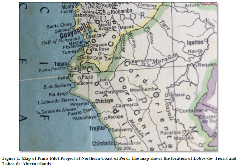
A reforestation of certain arid areas of the Peruvian coastline should be considered as a pilot project for this process. Specifically, receptive tourism in Peru is in danger of extinction because of the Covid pandemic, and activity in the tourism market, which gives employment to 1.5 million, mainly women, is in total collapse. Expected recovery of receptive tourism is proposed in a Pilot Project in the Piura region at the Northern coast of Peru. The tourism project will be actually located in Piura, near the Lobos-de-Tierra guano islands. The idea is to upgrade the existing ecological park, so that, respecting its current reality as a refuge for guano birds and sea lions, and becomes a habitat similar to the Galapagos Island in Ecuador. Upgrading of the ecological park can be done by the water net technique.
The location of the Piura Pilot Project is presented in the figure below. The two groups of islands considered in the Project are “Lobos de Tierra” and “Lobos de Afuera”. These two archipelagos are located south of the Piura coastline. Together they create a cluster of islands. This archipelago could be visited, in the future, by tourist cruises and they could become the “Peruvian Galapagos”. We proposed a reforestation project using water harvesting nets for all these islands.
Note that a project involving water nets and equipment, located in the Peruvian coast, would require a lot of security to preserve the investments inland. This is because land invaders are common in these areas. On the other hand, water-net investment located at the center of small islands would not require extreme security investments because these are uninhabited islands which are not at present occupied by people. These islands are only occupied by sealions, guano birds, penguins, etcetera (Figure 1).

Expectations are that tourists from developed countries will prefer Cruise Tourism because it will be regarded as safer, after the COVID Pandemic. This is because arriving by plane to Latin American cities will be, for the medium term, considered risky and dangerous. The high informality of our countries, whether real or perceived, will offer no guarantees to tourists, because they will continue for a time in fear of risk of contagion of COVID-19 mutations, and they may avoid hotels and sightseeing in cities in our exotic countries.
The argument here is that revival of the Peruvian economy must necessarily be based on the revival of external demand, rather than counting on the growth of domestic consumption. This is tantamount to say that only a revival of exports will reverse the decline in economic growth, as expectations of a significant recovery in domestic demand are nil. This is true for good exports as well as tourism exports.
The next section of the paper provides an analysis of the climatic conditions of the Peruvian coast. Section 3 discusses the economic considerations and section 4 presents the conclusions and policy recommendations.
THE CLIMATE OF THE PERUVIAN COAST
Peru is the climatical synthesis of the world, with great diversity of climates due to numerous factors such as the latitude of the country, the Andes, the Peruvian sea, and the El Niño current.
Due to its latitude, Peru has a geographical position of a tropical country. The territory extends from the equatorial line (0°01' south latitude) to the border with Chile (18°21' south latitude). The climate of the South American coast, as a consequence, should have been tropical, that is, hot, humid, rainy and with abundant vegetation. However, the Peruvian cost is a desert, and the tropical climate is only found in Peru in the Amazonian region; the climate of the coast and the Andean region are different and variable due to the influence of other factors.
The Andes constitutes the most important factor accounting for the climatic diversity of Peru. The mountains form the seven Peruvian regions or altitude floors: coast, yunga, quechua, suni, puna, and janca. To each of these regions corresponds a different climate. The temperature, the humidity, and the atmospheric pressure diminish with the altitude, and the wind is conditioned both in direction and velocity by the Andean range.
In summary, the Andes have divided Peru in two sides: the oriental very rainy jungle, where the trade winds discharge all their humidity in the form of torrential rains, and the arid occidental side, without rains in the lower zones and with scarce precipitation in the upper zones.
The Peruvian Pacific Ocean is one of the most important climatic factors of the coast. Its cold water determines the low atmospheric temperature, the absence of regular rains, the cloudy sky, and the arid landscape.
The Peruvian sea influences the coastal climate in various ways. First, it diminishes the temperature of the environment. In effect, the temperature of the coast should have been over 25°C due to Peru's tropical latitude. However, the yearly average temperature is only 18°C in Lima. The cause of this relatively low temperature is the cold water of the Peruvian sea, caused in turn by the Humboldt current, that lowers the temperature of the air right above. As an illustration, in the city of Bahia (Brazil) located at the same latitude than Lima, the average temperature is 25°C.
Second, the sea contributes to the formation of dense layers of stratum clouds that cover the coastal sky during most of the year. Those clouds, of dark gray color, are formed by the condensation of water vapor that is abundant in the coastal sky. Another cause for this phenomenon is the South Pacific anti-cyclone that, approaching the littoral, makes the air even colder and condenses the water vapor in small drops, thus forming the stratum clouds. The South Pacific anti-cyclone is a mass of cold and dry air going around the south pacific basin. During the winter time this mass approaches the Peru coast making the atmosphere colder and favoring the condensation of water vapor, that forms dense stratum clouds between 400 and 800 meters of altitude.
The ceiling of clouds acts as a barrier to solar rays, and it reflects the solar radiation back to the space. The coast is thus deprived of this energy and the “thermal inversion” phenomenon originates, which means that the temperature in the coast surface is lower than that at 900-meter altitude (the average temperature over the ceiling of stratum clouds is 24°C). This thermal inversion also creates the air stability phenomenon: the air does not ascend but remains still and there are no possibilities of regular rains.
Third, the sea forms the fogs and sea-mist of the coastal landscape. During the winter months (June-July-August) the presence of fogs on the coast and sea-mist on the sea surface even impede the visibility. In both cases it is condensed water vapor (small drops) in the air, produced by the cold surface of the coast and the cold sea waters, respectively.
Fourth, the Peruvian sea determines the absence of regular rains in the central and southern coast, except for the scarce precipitation on the hills (lomas) and on the northern coast (Tumbes, Piura). Only drizzles are observed, that is, very fine precipitation of the water drops making up the fogs and the stratum clouds. In Arequipa and Moquegua (Peruvian southern coast) these precipitations are called “camanchaca” (a Quichua word).
Again, there are no rains in the Peruvian coast due to the stability of the air. All water vapor gets stabilized under the ceiling of clouds, without enough energy to ascend. If the air were unstable is would ascend charged with humidity, which would condense after encountering colder zones, forming nimbus clouds. Only in the northern coast, the El Niño current breaks the thermal inversion, rising the temperature, and turning the air unstable, producing rains during the summer.
The El Niño current is one of hot waters that rises the temperature in the North, generating air instability and propitiating ascendant air currents, abundant humidity condensation and torrential summer rains, The El Niño current sometimes goes south between the Peru current and the littoral reaching the coast between Lima and Ica (central coast) and generating occasional irregular summer rains.
In conclusion, the Peruvian sea has influenced the climate converting the coast into a desert strip, interrupted only by small rivers descending from the Andes and forming 52 basins of very small extension.
However, the Peruvian sea influences likewise the formation of the loma hills. In the slightly elevated hills of the coast arid landscape appear the loma-hills as cellars of life. It is a peculiar phenomenon, formed by the association of herbal plants and bushes growing during the winter, covering with a dense vegetable carpet the hills near the sea. The stratum clouds humidify these hills and favor the development of the vegetation.
WATER-HARVESTING TECHNOLOGIES
The Piura Pilot Project
There are reports of new technologies of harvesting water from the clouds with plastic nets that holds out hope for thirsty deserts all around the world. One of these refers to a Chilean project to harvest water from the mountain mist to give new life to the Chungungu town, near La Serena [4].
In the desert around this tiny Pacific coast fishing village of 300 people, the low clouds that roll in from the ocean around dawn cover up the sky like a cataract and hang around just long enough not to drop any moisture on the ground.
For the people of the region, water was the major problem and it used to be trucked in, at great cost, from far away regions. But since early 1992, the trucks stopped bringing water to Chungungu. The poor town now has water aplenty: gardens bloom and new well-watered saplings have been planted in neat rows along the streets.
They have quenched their thirst without digging no wells, and the climate remains the same. A team of Chilean scientists have found a way to harvest the clouds. Atop the nearby mountain large plastic nets wait for the daily mist to roll in: water condenses on the nets, cascades down and flows through 4.3 miles of pipes to town. Its success holds out hope for clean and reliable drinking water for thirsty desert residents around the world.
The idea behind the cloud water system came from the once mysterious anomaly in the desert ecosystem. In some places, tops of mountains and high ocean-facing valleys had plant life common to areas with many times the average local precipitation. Studies of these ecosystems in the early 1960s discovered that these plants fulfilled almost all their water needs by grabbing it right out of the passing clouds. Condensing on the leaves, the droplets fell to the ground and trickled down to the roots.
The possibilities of adapting this phenomenon for human uses was immediately apparent, but there was little interest from the authorities, and the idea quietly died. It wasn't resurrected until 1980, when a new generation of scientist started the Chungungo project.
In 1985 CONAF established an experimental forest on top of El Tofo, the peak immediately behind Chungungu, to study the use of mist for reforestation. In 1987, with financial and technical help from the Canadian government, they began adapting their discoveries to provide water for Chungungu. On May 1992, after five more years of study and some Canadian funds to build collection nets, pipes, and storage tanks, the first “cloud-water” was delivered to Chungungu.
Technical considerations
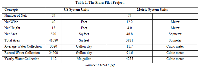
The figures summarizing the Chungungo project are given in the Table 1 below. All variables are estimated as units per hectare. Thus, the net area, in square feet turns out as 520 square feet per hectare; the collected harvested water turns out as 1.12 mn gallon per year.

The system is very efficient and very economic. On an average day the system collects 3080 gallons of water and the record collection is 24200 gallons. The system is also relatively cheap. If all cost of the Camanchaca project, including future maintenance, is included, water arrives at the tap for between 19 and 22 cents a gallon. By contrast, trucked polluted water cost about 44 cents a gallon (these prices are in domestic currency, pesos). The system produces 1.1 million gallons-year, which is valued about 11thousand US$ (average cost of tap water in the US is only $1 cent per gallon). The system requires no pumps or outside energy to function nor does the cloud-water need to be chemically treated.
This paper intends discusses now the technical and economic viability of adapting the above technology for the purpose of reforestation of the vast arid areas of the Pacific South-American coastline (Peru and Chile). The project may represent really an effort to replant the mountain top forests and bushes destroyed by man in the past centuries for timber and firewood.
The needs of water for a process of reforesting the desert coast are difficult to measure. However, let us assume that what is needed to regenerate a secondary forest is an additional yearly precipitation of 500 mm (in addition to the normal drizzles). This would amount to a yearly need equal to 5000 cubic meters of water for every hectare. As one can see from table 1 the Chungungo project produces a little less than this total (4255 cubic meter per year).
Therefore, a reforestation project would require 17% additional net area than the Chungungo project to regenerate a secondary forest after two or three years. Two things are worth noting. First, once a secondary forest is regenerated the plants may fulfill their water needs by grabbing it from the passing mist, condensing it on the leaves, and letting it fell to the ground and the roots (as was observed above). Second, the nets may be used time and time again which reduces the initial investment.
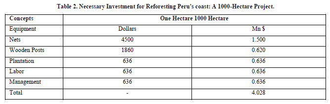
The minimum investment requirements to reforest one hectare are given in the Table 2 below. An initial pilot project for reforesting 1000 hectares is also assumed in the calculations.

In summary, the total investment amounts to $4028 per hectare when the equipment is used for every 3-hectares. The daily needs of water for reforestation were estimated as 13.7 cubic meters/ ha (equivalent to 5000 cubic meters/year). The net area needs to fulfill these requirements (assuming the same extraction rates of the Chungungo project above) is 4485 sq meters, and the number of nets needed are 93 units (assuming the same net size). This will give a total length equal to 1132 meters that should be arranged in rows, spaced at 10 meters each, covering the whole hectare.
Note that the cost calculations are made assuming that the nets and wooden posts are to be used three times, moving them every three years. Thus, a 1000 ha project would make use of the same equipment and the average investment per hectare is reduced to 4028 dollars for a total cost of near 4 million dollars, and the project disbursements would span over nine years.
The irrigation system is very simple, only using collection nets that condense the mist and let the drops fall to the ground. No canals, pipes, or storage devices are needed as in the case of an urban water project.
To complete the social cost-benefit analysis of the project a measure of the potential benefits of the reforested area is needed. The lower bound of benefits would be using this land as pasture-land. If we were to use the new land for livestock we may use the fact that the average profit per cow in the central plains of North America is given by Halich [6]. These authors argue that at $1.55/lb price (for the steer) the return to land and labor is estimated by the authors as $119/cow/year. This assumes 2.0 acres of pasture per cow. If we consider that one hectare equals 2.47 acres this means that the profit per hectare would be $147/hectare/year. Thus, the average return to land and labor per hectare is about $150. Note that we should use the return-to-land estimate, which we do not have. When comparing these benefits to the initial investment of $4028/hectare, the results would be under 5% return on investment, a very low rate indeed. Finally, the upper bound of benefits would be the returns if we were to sell the water as tap water for an urban project. We estimated the sales would be $11 thousand per year per hectare, but this is a quite different project.
The benefits from the mere existence of the new forest are even more difficult to evaluate. Because one can make some estimates of the potential output of some agricultural and forestry products that may come from the project. But how are we to value the environmental benefits on climate and on people brought about by the rebirth of a forest or by a new forest? A review of alternative methods of valuating forests is presented in Tietenberg [1].
This benefit side of the analysis is therefore only approximate and non-numerical. The main use that the reforested areas may be put to is agroforestry production systems, which may include timber, perennial semi-tropical crops (lucuma, pacay, pepino, basul), medicinal herbs and pasture crops. Estimation of average product yields for these alternative crops as well as estimation of output and input prices would require further research.
Agroforestry systems are gaining widespread recognition these days. In this production system shrubs and trees are grown together with food or plantation crops and even livestock (South American Camelidae). Such systems can be highly productive and resistant to perturbation, and they represent a major thrust in sustainable agriculture [7]. The proposed perennial semi-tropical crops are taken from this publication and discussed next.
Regarding the semi-tropical crops, Lucuma (pouteria lucuma) is a tree providing a staple fruit, rich in starch and a basic everyday source of carbohydrate and calories; besides feeding people, lucuma fruits are fed to chickens. Pacay (inga species) is a tree that produces long pods filled with soft sweet white pulp; pacay tree grows rapidly, is tolerant of diverse soils, and resistant to diseases and fire; they are easy to establish, spread their shade quickly, and provide fruits for years [7]. Pepino (solanorum muricatum) is a large conical yellow fruit already popular in New Zealand and Japan; the plant is undemanding and has wide adaptation to altitude, latitude and soils; established bushes show tolerance to drought stress quickly recovering vegetative growth [7]. Basul (erythrina edulis) is a common leguminous tree producing large edible seeds; it has promise as a perennial high-protein crop for subtropical areas [7].
Likewise, it would be necessary to advance some economic measure of the environmental benefits stemming from the mere existence of forest (and greater biodiversity), even if no commercial output is extracted from them. In any case, previous knowledge and common sense would suggest that the benefits stemming from one hectare of new forest in this part of the world should be higher than the estimated 4-thousand-dollar cost and that the project should be economically viable with a sufficiently high internal rate of return.
Finally, a mention should be made to a pioneer reforestation effort implemented since the 1950s in the Peruvian central coast. Lachay Lomas, 120 kms north of Lima, is a pilot experiment of what can be expected from the use of fogs for reforestation purposes with the old technology. Lachay Lomas is well orientated with respect to the ocean and they are located between 500 and 800 meters above sea level, which seems to be ideal for the concentration of humidity. However, the area has to be fenced off to protect it from the animals-principally goats-that would destroy all vegetation if allowed to enter.
CONCLUSIONS AND RECOMMENDATIONS
Some conclusions and recommendations may be presented now. First, although the cold waters of the Peruvian sea have influenced the climate converting the coast into a desert strip, it contributes at the same time to the formation of dense layers of stratum clouds that cover the Peruvian coastal sky during most of the year. The paradox is that the coastal air, especially in the central coast, has a very high concentration of humidity but no rain is produced. It may be posed that nowhere else in the American continent this situation of dry weather and high humidity is present to the same degree.
Second, there are reports of already-validated new technologies of harvesting water from the clouds with plastic nets, that brings hope to the practical possibilities of converting the humidity-charged coastal air in Peru into actual precipitations.
Third, the technical and economic viability of adapting the water-harvesting technologies for the purposes of reforestation of the vast arid areas of the Peruvian coastline is shown to be valid. Furthermore, the discussion above suggests that a social cost-benefit analysis of a pilot reforestation project would show fairly low monetary costs and very important potential benefits of the reforested area in the form of agroforestry, timber, perennial semi-tropical crops, medicinal herbs, and pastures/forage as well as other environmental benefits stemming from the mere existence of forest and a greater biodiversity, even if no commercial output is extracted from them.
Finally, as an antecedent for recommendations, two very important restriction for implementing the type of reforestation project suggested above should be mentioned: security and land tenancy.
Regarding security, we all know about the disruption being caused by the drug traffickers, who have launched an armed campaign of terror in the Peruvian highlands and in the coast. As in Lomas-Lachay the reforested reserve may have to be fenced and heavily guarded against depredation, fires, and terrorism. The recommended action here is to ask the military to be the executing agency of the project. The benefits of this measure should be evident, in terms of strengthening the concerned institutions by taking over the government responsibility for defending common property natural resources and the environment, and in terms of creating good public image for the military institutions, both at home and abroad.
Civil war in Peru was present from 1980 to 1995, when Shining Path guerrilla-warfare was dwelling. The impacts of this war include 23.000 people dead and more than 20 billion dollars in cost, about the same size of Peru's external debt at the time. The armed conflict had other important impacts on people and the environment. Forced migration of indigenous people, deforestation and colonization of tropical forests, degraded areas and ecosystems, loss of biodiversity, are all consequences of the armed conflict and the drug traffic in the Andes, the jungle, and the coast of Peru since 1980. Pacification after 2000 involved reallocation of resources from war activities to peace activities and one central thesis advanced here is that resources in Peru today may be reallocated to activities oriented to development, conservation, and management of natural resources in this country.
Land tenancy is a very important issue in Peru and the problems may become unsurmountable once the arid desert ceases to have no value to people. The land titling system in Peru is in shambles. There is no cadaster of land not a clear identification of property owners. It was implicitly assumed that the reforested land of the project proposed above should be a common property owned by the state, but this situation should be clarified from the beginning to avoid future claims on the land. Besides, the reforestation projects should not be limited to public projects; it is possible to think of desert land concessions to private parties or NGOs for the purpose of private financing of reforestation efforts. The financing of these private projects could make use of the debt-for-nature swaps mechanisms in vogue today.
No Files Found


Internationally Accepted
Share Your Publication :